
Skip to content
HeliSafe Surveyor

The Platform

One record of every site you operate to

HeliSafe Surveyor holds the survey, the plate and the approval trail for every landing site in one place, so the current position is never in doubt and the history is always retrievable.

What a completed survey produces

DOC 01
HLS Plate
The site diagram carried by the crew, versioned and reissued when the site changes
DOC 02
Survey Information Form
The full structured record of obstacles, dimensions, surface and access
DOC 03
Compliance Statement
The survey set against the guidance framework the operator works to
DOC 04
Landowner Permission
Recorded consent for sites that need it, held against the survey
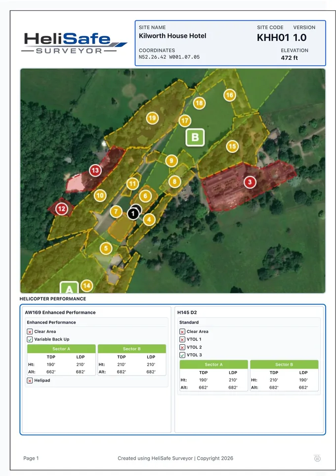
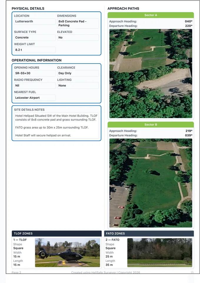
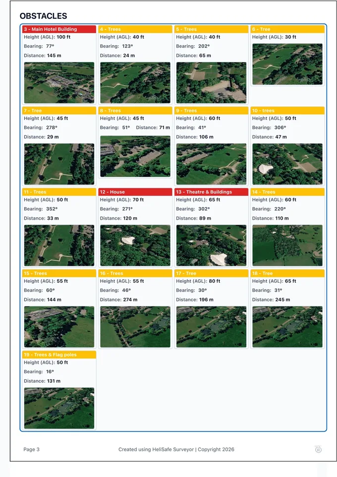
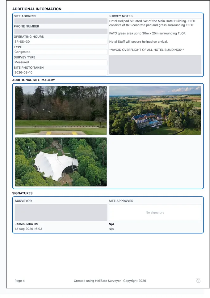
HLS plate page 1 — site header, map with numbered obstacles and aircraft performance dataHLS plate page 2 — physical and operational detail, approach paths and zone dimensionsHLS plate page 3 — seventeen recorded obstacles with height, bearing, distance and photographHLS plate page 4 — site information, additional imagery and signatures

Example plate · Four pages · Seventeen obstacles recorded

Survey capture

Structured, not freeform

Obstacles, zone geometry, approach and departure sectors, surface condition and access are recorded against a consistent template rather than typed into notes. Every survey carries its own revision history, so what was known and when is always answerable.
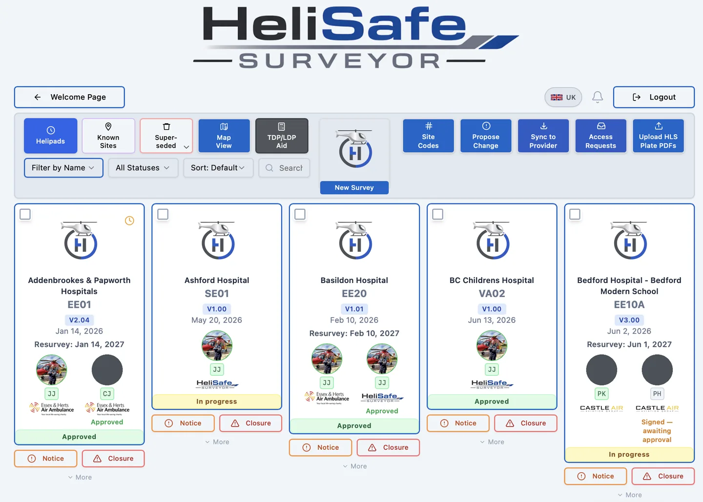
The HeliSafe Surveyor surveys list, showing sites with version numbers, resurvey dates, approval status and named sign-off

Plate generation

The plate comes from the survey

The site diagram is generated directly from the survey record, so the document in the cockpit and the data behind it cannot drift apart. When the site changes, the plate is reissued rather than redrawn.

  • Site diagram
  • Zone geometry
  • Obstacle annotation
  • Approach & departure sectors
  • Version controlled reissue

Controlled sharing

Share a site without handing over your account

Surveys can be shared between operators and with hospital teams at defined access levels, so a site can be read by the people who need it without exposing everything else. Access is granted per company, not per file.

  • Per-company access
  • Defined access levels
  • Operator to operator
  • Hospital team access
  • No account sharing

Approval and sign-off

Every approval is attributable

Sites are signed off by named individuals against a specific survey revision, with the date recorded. An approval always points at the version it was given for.

  • Named approver
  • Bound to a revision
  • Date recorded
  • Approval history retained

Closures and short term notices

Tell crews what changed, today

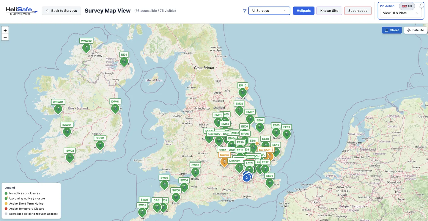
Temporary closures and short term notices are raised against a site and surfaced immediately, with the period they apply for. Crews see the current state of the site, not last month’s.

The HeliSafe Surveyor map view, showing landing sites across the UK and Ireland with current status
Peter Kersey, Pilot, MAGPAS Air Ambulance

We are so happy to be leading the way in Helipad survey and management within the UK HEMS sector, HeliSafe Surveyor is revolutionary for our operations.

Peter Kersey · Pilot · MAGPAS Air Ambulance

Access that matches the role

Not everyone who needs to see a landing site needs to edit one. HeliSafe Surveyor separates the people who survey from the people who keep a site’s status current, and from the people who simply need to know a site is serviceable before a crew departs. Access is set per user, and the right to sign off a site is granted separately, to named individuals.

Admin
Manages their own organisation’s users and access levels
Standard user
Creates and maintains survey records
Viewer
Sees current plates and site status, without edit rights
Ground operations
Records site notices and closures against their organisation’s sites
Hospital manager
Sees the sites relevant to their own location, and can record notices and closures against them
Training only
Access to the training platform, without access to survey records

Site approval is separate from access level. It is granted to named individuals, and every sign-off is recorded against the survey revision it applied to.

The plate belongs in the cockpit, not just in HeliSafe

A survey is only useful if it reaches the crew. HeliSafe pushes current, approved plates out to the electronic flight bags operators already use, so nobody is carrying a plate that has been superseded.

ForeFlight

A content pack your crews subscribe to.

HeliSafe builds a ForeFlight content pack from your approved surveys: every site as a waypoint, its plate attached as a linked document, and a labelled map layer across the whole directory. Crews follow one link and the pack installs itself. Rebuild it when sites change and an administrator approves the new version before it reaches anyone.

Approved surveys only · Current version · Admin approval before release

Airbox

Changed plates, sent for loading.

For operators using Airbox, HeliSafe works out which plates have actually changed since the last time and sends just those to the Airbox GIS team as secure, time-limited download links, with your own administrators copied. You review exactly what is going before it goes.

Differential: only what changed · Links expire after seven days · Reviewed before sending

API access

Your data, in the systems you already run.

Survey data can be made available to other systems an operator runs, through a scoped interface. Keys are issued by us against a named authorisation, scoped to what that integration actually needs, and revoked the same way. Rate limits apply per key, and every issued key is recorded.

Scoped keys · Issued against a named authorisation · Rate limited · Available on Enterprise

ForeFlight and Airbox are trade marks of their respective owners. HeliSafe Surveyor is not affiliated with either.

See it against one of your own sites

A twenty minute call, using a landing site you already operate to.

Book a demo